Sitemap
A list of all the posts and pages found on the site. For you robots out there is an XML version available for digesting as well.
Pages
Posts
Solving a game called ‘ball sort puzzle’
Published:
Countries of the world quiz
Published:
Solving NYTimes ‘Letter Boxed’ puzzles
Published:
Flipping blueberry pancakes
Published:
How to reproduce ImageNet validation results
Published:
Understanding intersection-over-union
Published:
Partitioning US counties with migration data
Published:
Anonymous inner functions in JavaScript
Published:
Accrete solar system simulator
Published:
portfolio
Portfolio item number 1
Short description of portfolio item number 1
Portfolio item number 2
Short description of portfolio item number 2
publications
Sparse Local Binary Pattern Histograms for Face Recognition with Limited Training Samples
Caleb Robinson, Jianxia Xue. "Sparse Local Binary Pattern Histograms for Face Recognition with Limited Training Samples." 2014 ACM Southeast Regional Conference, 2014.
An Approach to Integrate Inter-dependent Simulations using HLA with Applications to Sustainable Urban Development
Ajitesh Jain, Caleb Robinson, Bistra Dilkina, Richard Fujimoto. "An Approach to Integrate Inter-dependent Simulations using HLA with Applications to Sustainable Urban Development." 2016 Winter Simulation Conference (WSC), 2016.
Network Optimization of Food Flows in the U.S.
Caleb Robinson, Arezoo Shirazi, Mengmeng Liu, Bistra Dilkina. "Network Optimization of Food Flows in the U.S.." 2016 IEEE International Conference on Big Data (Big Data), 2016.
A Deep Learning Approach for Population Estimation from Satellite Imagery
Caleb Robinson, Fred Hohman, Bistra Dilkina. "A Deep Learning Approach for Population Estimation from Satellite Imagery." 1st ACM SIGSPATIAL Workshop on Geospatial Humanities (GeoHumanities), 2017.
Machine Learning Approaches for Estimating Commercial Building Energy Consumption
Caleb Robinson, Bistra Dilkina, Jeffrey Hubbs, Wenwen Zhang, Subhrajit Guhathakurta, Marilyn Brown, Ram Pendyala. "Machine Learning Approaches for Estimating Commercial Building Energy Consumption." Applied Energy, 2017.
A Machine Learning Approach to Modeling Human Migration
Caleb Robinson, Bistra Dilkina. "A Machine Learning Approach to Modeling Human Migration." 1st ACM SIGCAS Conference on Computing and Sustainable Societies (COMPASS), 2018.
Estimating Residential Energy Consumption in Metropolitan Areas: A Microsimulation Approach
Wenwen Zhang, Caleb Robinson, Subhrajit Guhathakurta, Venu Garikapati, Bistra Dilkina, Marilyn Brown, Ram Pendyala. "Estimating Residential Energy Consumption in Metropolitan Areas: A Microsimulation Approach." Energy, 2018.
Infrastructure Resilience for Climate Adaptation
Caleb Robinson*, Amrita Gupta*, Bistra Dilkina. "Infrastructure Resilience for Climate Adaptation." 1st ACM SIGCAS Conference on Computing and Sustainable Societies (COMPASS), 2018.
Toward a Common Object Model for Integrated Transportation and Land Use Models
Caleb Robinson, John Crittenden, Zhongming Lu, Richard Fujimoto. "Toward a Common Object Model for Integrated Transportation and Land Use Models." 51st Annual Simulation Symposium (ANSS), 2018.
Label Super-Resolution Networks
Kolya Malkin, Caleb Robinson, Le Hou, Rachel Soobitsky, Jacob Czawlytko, Dimitris Samaras, Joel Saltz, Lucas Joppa, Nebojsa Jojic. "Label Super-Resolution Networks." International Conference on Learning Representations (ICLR), 2019.
Large Scale High-Resolution Land Cover Mapping with Multi-Resolution Data
Caleb Robinson, Le Hou, Kolya Malkin, Rachel Soobitsky, Jacob Czawlytko, Bistra Dilkina, Nebojsa Jojic. "Large Scale High-Resolution Land Cover Mapping with Multi-Resolution Data." IEEE/CVF Conference on Computer Vision and Pattern Recognition (CVPR), 2019.
Human-Machine Collaboration for Fast Land Cover Mapping
Caleb Robinson, Anthony Ortiz, Kolya Malkin, Blake Elias, Andi Peng, Dan Morris, Bistra Dilkina, Nebojsa Jojic. "Human-Machine Collaboration for Fast Land Cover Mapping." AAAI Conference on Artificial Intelligence (AAAI), 2020.
Local Context Normalization: Revisiting Local Normalization
Anthony Ortiz, Caleb Robinson, Dan Morris, Olac Fuentes, Christopher Kiekintveld, Md Hassan, Nebojsa Jojic. "Local Context Normalization: Revisiting Local Normalization." IEEE/CVF Conference on Computer Vision and Pattern Recognition (CVPR), 2020.
Machine Learning for Decision Support in Wildlife Conservation and Land Management
Dan Morris, Siyu Yang, Caleb Robinson, Nebojsa Jojic. "Machine Learning for Decision Support in Wildlife Conservation and Land Management." ESA Annual Meeting, 2020.
Model Generalization in Deep Learning Applications for Land Cover Mapping
Lucas Hu, Caleb Robinson, Bistra Dilkina. "Model Generalization in Deep Learning Applications for Land Cover Mapping." arXiv preprint arXiv:2008.10351, 2020.
Modeling Migration Patterns in the USA Under Sea Level Rise
Caleb Robinson, Bistra Dilkina, Juan Moreno-Cruz. "Modeling Migration Patterns in the USA Under Sea Level Rise." Plos one, 2020.
SUMMIT: Scaling Deep Learning Interpretability by Visualizing Activation and Attribution Summarizations
Fred Hohman, Haekyu Park, Caleb Robinson, Duen Chau. "SUMMIT: Scaling Deep Learning Interpretability by Visualizing Activation and Attribution Summarizations." IEEE Transactions on Visualization and Computer Graphics (TVCG), 2020.
Weakly Supervised Semantic Segmentation in the 2020 IEEE GRSS Data Fusion Contest
Caleb Robinson, Kolya Malkin, Lucas Hu, Bistra Dilkina, Nebojsa Jojic. "Weakly Supervised Semantic Segmentation in the 2020 IEEE GRSS Data Fusion Contest." International Geoscience and Remote Sensing Symposium (IGARSS), 2020.
2021 Data Fusion Contest: Geospatial Artificial Intelligence for Social Good Technical Committees
Naoto Yokoya, Pedram Ghamisi, Ronny H{\"a}nsch, Colin Prieur, Hana Malha, Jocelyn Chanussot, Caleb Robinson, Kolya Malkin, Nebojsa Jojic. "2021 Data Fusion Contest: Geospatial Artificial Intelligence for Social Good Technical Committees." IEEE Geoscience and Remote Sensing Magazine (GRSM), 2021.
Becoming Good at AI for Good
Meghana Kshirsagar, Caleb Robinson, Siyu Yang, Shahrzad Gholami, Ivan Klyuzhin, Sumit Mukherjee, Md Nasir, Anthony Ortiz, Felipe Oviedo, Darren Tanner, Anusua Trivedi, Yixi Xu, Ming Zhong, Bistra Dilkina, Rahul Dodhia, Juan Ferres. "Becoming Good at AI for Good." 2021 AAAI/ACM Conference on AI, Ethics, and Society (AIES), 2021.
Detecting Cattle and Elk in the Wild from Space
Caleb Robinson, Anthony Ortiz, Lacey Hughey, Jared Stabach, Juan Ferres. "Detecting Cattle and Elk in the Wild from Space." arXiv preprint arXiv:2106.15448, 2021.
From Local Algorithms to Global Results: Human-machine Collaboration for Robust Analysis of Geographically Diverse Imagery
Nebojsa Jojic, Nikolay Malkin, Caleb Robinson, Anthony Ortiz. "From Local Algorithms to Global Results: Human-machine Collaboration for Robust Analysis of Geographically Diverse Imagery." International Geoscience and Remote Sensing Symposium (IGARSS), 2021.
Global Land-Cover Mapping with Weak Supervision: Outcome of the 2020 IEEE GRSS Data Fusion Contest
Caleb Robinson, Kolya Malkin, Nebojsa Jojic, Huijun Chen, Rongjun Qin, Changlin Xiao, Michael Schmitt, Pedram Ghamisi, Ronny H{\"a}nsch, Naoto Yokoya. "Global Land-Cover Mapping with Weak Supervision: Outcome of the 2020 IEEE GRSS Data Fusion Contest." IEEE Journal of Selected Topics in Applied Earth Observations and Remote Sensing (J-STARS), 2021.
High-Resolution Land Cover Change from Low-Resolution Labels: Simple Baselines for the 2021 IEEE GRSS Data Fusion Contest
Nikolay Malkin, Caleb Robinson, Nebojsa Jojic. "High-Resolution Land Cover Change from Low-Resolution Labels: Simple Baselines for the 2021 IEEE GRSS Data Fusion Contest." arXiv preprint arXiv:2101.01154, 2021.
Reducing Bias and Increasing Utility by Federated Generative Modeling of Medical Images using a Centralized Adversary
Jean-Francois Rajotte, Sumit Mukherjee, Caleb Robinson, Anthony Ortiz, Christopher West, Juan Ferres, Raymond Ng. "Reducing Bias and Increasing Utility by Federated Generative Modeling of Medical Images using a Centralized Adversary." Conference on Information Technology for Social Good (GoodIT), 2021.
Report on the 2021 IEEE GRSS Data Fusion Contest—Geospatial Artificial Intelligence for Social Good [Technical Committees]
Naoto Yokoya, Pedram Ghamisi, Ronny H{\"a}nsch, Colin Prieur, Hana Malha, Jocelyn Chanussot, Caleb Robinson, Kolya Malkin, Nebojsa Jojic. "Report on the 2021 IEEE GRSS Data Fusion Contest—Geospatial Artificial Intelligence for Social Good [Technical Committees]." IEEE Geoscience and Remote Sensing Magazine, 2021.
Temporal Cluster Matching for Change Detection of Structures from Satellite Imagery
Caleb Robinson, Anthony Ortiz, Juan Ferres, Brandon Anderson, Daniel Ho. "Temporal Cluster Matching for Change Detection of Structures from Satellite Imagery." ACM SIGCAS Conference on Computing and Sustainable Societies, 2021.
An Artificial Intelligence Dataset for Solar Energy Locations in India
Anthony Ortiz, Dhaval Negandhi, Sagar Mysorekar, Shivaprakash Nagaraju, Joseph Kiesecker, Caleb Robinson, Priyal Bhatia, Aditi Khurana, Jane Wang, Felipe Oviedo, Juan Ferres. "An Artificial Intelligence Dataset for Solar Energy Locations in India." Scientific Data, 2022.
Deep Learning Models for COVID-19 Chest X-Ray Classification: Preventing Shortcut Learning Using Feature Disentanglement
Caleb Robinson, Anusua Trivedi, Marian Blazes, Anthony Ortiz, Jocelyn Desbiens, Sunil Gupta, Rahul Dodhia, Pavan Bhatraju, W Liles, Jayashree Kalpathy-Cramer, Juan Ferres. "Deep Learning Models for COVID-19 Chest X-Ray Classification: Preventing Shortcut Learning Using Feature Disentanglement." Plos one, 2022.
Effective Deep Learning Approaches for Predicting COVID-19 Outcomes from Chest Computed Tomography Volumes
Anthony Ortiz, Anusua Trivedi, Jocelyn Desbiens, Marian Blazes, Caleb Robinson, Sunil Gupta, Rahul Dodhia, Pavan Bhatraju, W Liles, Aaron Lee, Juan Ferres. "Effective Deep Learning Approaches for Predicting COVID-19 Outcomes from Chest Computed Tomography Volumes." Scientific Reports, 2022.
Fast Building Segmentation from Satellite Imagery and Few Local Labels
Caleb Robinson, Anthony Ortiz, Hogeun Park, Nancy Lozano, Jon Kaw, Tina Sederholm, Rahul Dodhia, Juan Ferres. "Fast Building Segmentation from Satellite Imagery and Few Local Labels." IEEE/CVF Conference on Computer Vision and Pattern Recognition (CVPR), 2022.
Mapping Industrial Poultry Operations at Scale with Deep Learning and Aerial Imagery
Caleb Robinson, Ben Chugg, Brandon Anderson, Juan Ferres, Daniel Ho. "Mapping Industrial Poultry Operations at Scale with Deep Learning and Aerial Imagery." IEEE Journal of Selected Topics in Applied Earth Observations and Remote Sensing (J-STARS), 2022.
On the Deployment of Post-Disaster Building Damage Assessment Tools using Satellite Imagery: A Deep Learning Approach
Shahrzad Gholami, Caleb Robinson, Anthony Ortiz, Siyu Yang, Jacopo Margutti, Cameron Birge, Rahul Dodhia, Juan Ferres. "On the Deployment of Post-Disaster Building Damage Assessment Tools using Satellite Imagery: A Deep Learning Approach." International Conference on Data Mining Workshops (ICDMW), 2022.
The Outcome of the 2021 IEEE GRSS Data Fusion Contest—Track MSD: Multitemporal Semantic Change Detection
Zhuohong Li, Fangxiao Lu, Hongyan Zhang, Lilin Tu, Jiayi Li, Xin Huang, Caleb Robinson, Nikolay Malkin, Nebojsa Jojic, Pedram Ghamisi, Ronny H{\"a}nsch, Naoto Yokoya. "The Outcome of the 2021 IEEE GRSS Data Fusion Contest—Track MSD: Multitemporal Semantic Change Detection." IEEE Journal of Selected Topics in Applied Earth Observations and Remote Sensing (J-STARS), 2022.
Torchgeo: Deep Learning with Geospatial Data
Adam Stewart, Caleb Robinson, Isaac Corley, Anthony Ortiz, Juan Ferres, Arindam Banerjee. "Torchgeo: Deep Learning with Geospatial Data." 30th International Conference on Advances in Geographic Information Systems (SIGSPATIAL), 2022.
Resolving Label Uncertainty with Implicit Posterior Models
Esther Rolf, Nikolay Malkin, Alexandros Graikos, Ana Jojic, Caleb Robinson, Nebojsa Jojic. "Resolving Label Uncertainty with Implicit Posterior Models." Thirty-Eighth Conference on Uncertainty in Artificial Intelligence (UAI), 2022.
A Biologist's Guide to the Galaxy: Leveraging Artificial Intelligence and Very High-Resolution Satellite Imagery to Monitor Marine Mammals from Space
Christin Khan, Kimberly Goetz, Hannah Cubaynes, Caleb Robinson, Erin Murnane, Tyler Aldrich, Meredith Sackett, Penny Clarke, Michelle LaRue, Timothy White, Kathleen Leonard, Anthony Ortiz, Juan Ferres. "A Biologist's Guide to the Galaxy: Leveraging Artificial Intelligence and Very High-Resolution Satellite Imagery to Monitor Marine Mammals from Space." Journal of Marine Science and Engineering, 2023.
Harnessing AI and Robotics in Humanitarian Assistance and Disaster Response
Thomas Manzini, Robin Murphy, Eric Heim, Caleb Robinson, Guido Zarrella, Ritwik Gupta. "Harnessing AI and Robotics in Humanitarian Assistance and Disaster Response." Science robotics, 2023.
Mask Conditional Synthetic Satellite Imagery
Van Le, Varshini Reddy, Zixi Chen, Mengyuan Li, Xinran Tang, Anthony Ortiz, Simone Nsutezo, Caleb Robinson. "Mask Conditional Synthetic Satellite Imagery." arXiv preprint arXiv:2302.04305, 2023.
Open Data on GitHub: Unlocking the Potential of AI
Anthony Roman, Kevin Xu, Arfon Smith, Jehu Vega, Caleb Robinson, Juan Ferres. "Open Data on GitHub: Unlocking the Potential of AI." arXiv preprint arXiv:2306.06191, 2023.
Open Datasheets: Machine-readable Documentation for Open Datasets and Responsible AI Assessments
Anthony Roman, Jennifer Vaughan, Valerie See, Steph Ballard, Nicolas Schifano, Jehu Torres, Caleb Robinson, Juan Ferres. "Open Datasheets: Machine-readable Documentation for Open Datasets and Responsible AI Assessments." arXiv preprint arXiv:2312.06153, 2023.
Poverty Rate Prediction using Multi-Modal Survey and Earth Observation Data
Simone Fobi, Manuel Cardona, Elliott Collins, Caleb Robinson, Anthony Ortiz, Tina Sederholm, Rahul Dodhia, Juan Ferres. "Poverty Rate Prediction using Multi-Modal Survey and Earth Observation Data." 6th ACM SIGCAS/SIGCHI Conference on Computing and Sustainable Societies (COMPASS), 2023.
Rapid Building Damage Assessment Workflow: An Implementation for the 2023 Rolling Fork, Mississippi Tornado Event
Caleb Robinson, Simone Nsutezo, Anthony Ortiz, Tina Sederholm, Rahul Dodhia, Cameron Birge, Kasie Richards, Kris Pitcher, Paulo Duarte, Juan Ferres. "Rapid Building Damage Assessment Workflow: An Implementation for the 2023 Rolling Fork, Mississippi Tornado Event." IEEE/CVF International Conference on Computer Vision (ICCV), 2023.
Revisiting Pre-trained Remote Sensing Model Benchmarks: Resizing and Normalization Matters
Isaac Corley, Caleb Robinson, Rahul Dodhia, Juan Ferres, Peyman Najafirad. "Revisiting Pre-trained Remote Sensing Model Benchmarks: Resizing and Normalization Matters." arXiv preprint arXiv:2305.13456, 2023.
SatCLIP: Global, General-Purpose Location Embeddings with Satellite Imagery
Konstantin Klemmer, Esther Rolf, Caleb Robinson, Lester Mackey, Marc Ru{\ss}wurm. "SatCLIP: Global, General-Purpose Location Embeddings with Satellite Imagery." arXiv preprint arXiv:2311.17179, 2023.
The Road to India's Renewable Energy Transition Must Pass through Crowded Lands
Joseph Kiesecker, Shivaprakash Nagaraju, James Oakleaf, Anthony Ortiz, Juan Ferres, Caleb Robinson, Srinivas Krishnaswamy, Raman Mehta, Rahul Dodhia, Jeffrey Evans, Michael Heiner, Pratiti Priyadarshini, Pooja Chandran, Kei Sochi. "The Road to India's Renewable Energy Transition Must Pass through Crowded Lands." Land, 2023.
A Change Detection Reality Check
Isaac Corley, Caleb Robinson, Anthony Ortiz. "A Change Detection Reality Check." arXiv preprint arXiv:2402.06994, 2024.
Bootstrapping Rare Object Detection in High-Resolution Satellite Imagery
Akram Zaytar, Caleb Robinson, Gilles Hacheme, Girmaw Tadesse, Rahul Dodhia, Juan Ferres, Lacey Hughey, Jared Stabach, Irene Amoke. "Bootstrapping Rare Object Detection in High-Resolution Satellite Imagery." arXiv preprint arXiv:2403.02736, 2024.
Mission Critical–Satellite Data is a Distinct Modality in Machine Learning
Esther Rolf, Konstantin Klemmer, Caleb Robinson, Hannah Kerner. "Mission Critical--Satellite Data is a Distinct Modality in Machine Learning." arXiv preprint arXiv:2402.01444, 2024.
SSL4EO-L: Datasets and Foundation Models for Landsat Imagery
Adam Stewart, Nils Lehmann, Isaac Corley, Yi Wang, Yi-Chia Chang, Nassim Ait, Shradha Sehgal, Caleb Robinson, Arindam Banerjee. "SSL4EO-L: Datasets and Foundation Models for Landsat Imagery." Advances in Neural Information Processing Systems (NeurIPS), 2024.
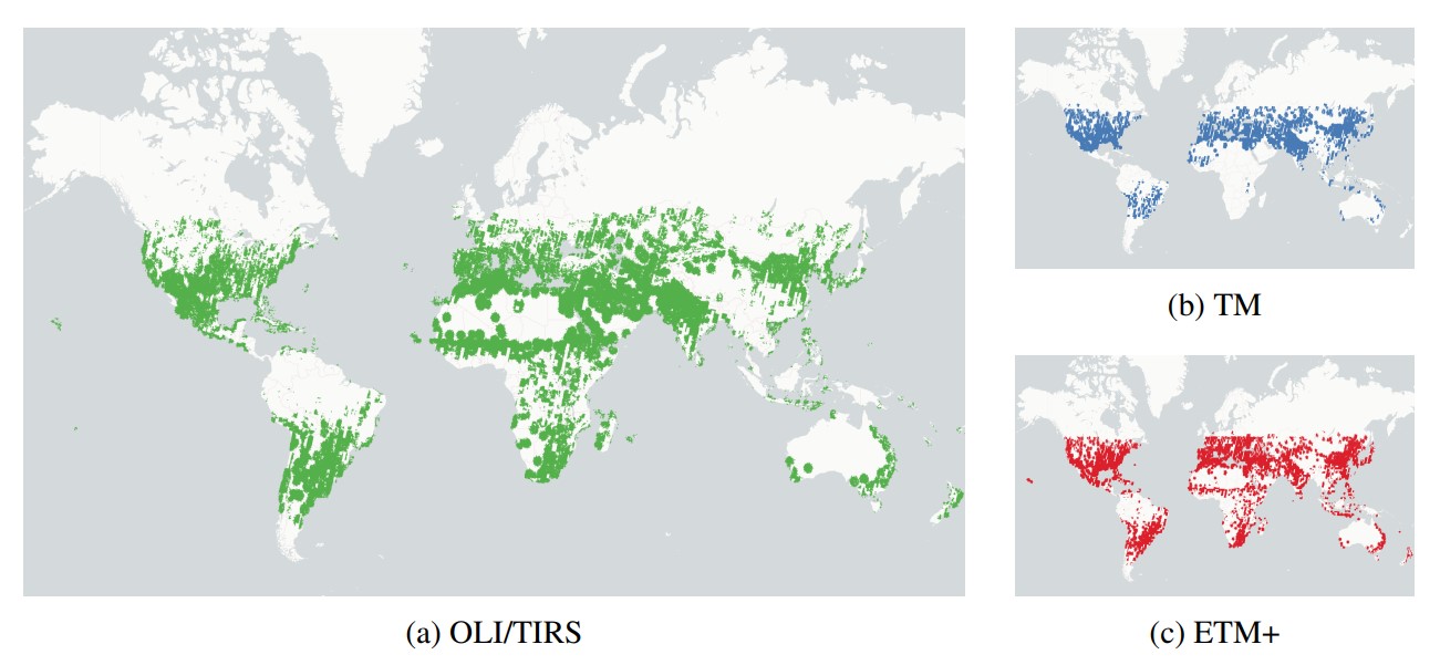 | We introduce SSL4EO-L, the first ever dataset designed for self-supervised learning for Earth Observation for the Landsat family of satellites. |
Seeing the Roads Through the Trees: A Benchmark for Modeling Spatial Dependencies with Aerial Imagery
Caleb Robinson, Isaac Corley, Anthony Ortiz, Rahul Dodhia, Juan Ferres, Peyman Najafirad. "Seeing the Roads Through the Trees: A Benchmark for Modeling Spatial Dependencies with Aerial Imagery." arXiv preprint arXiv:2401.06762, 2024.
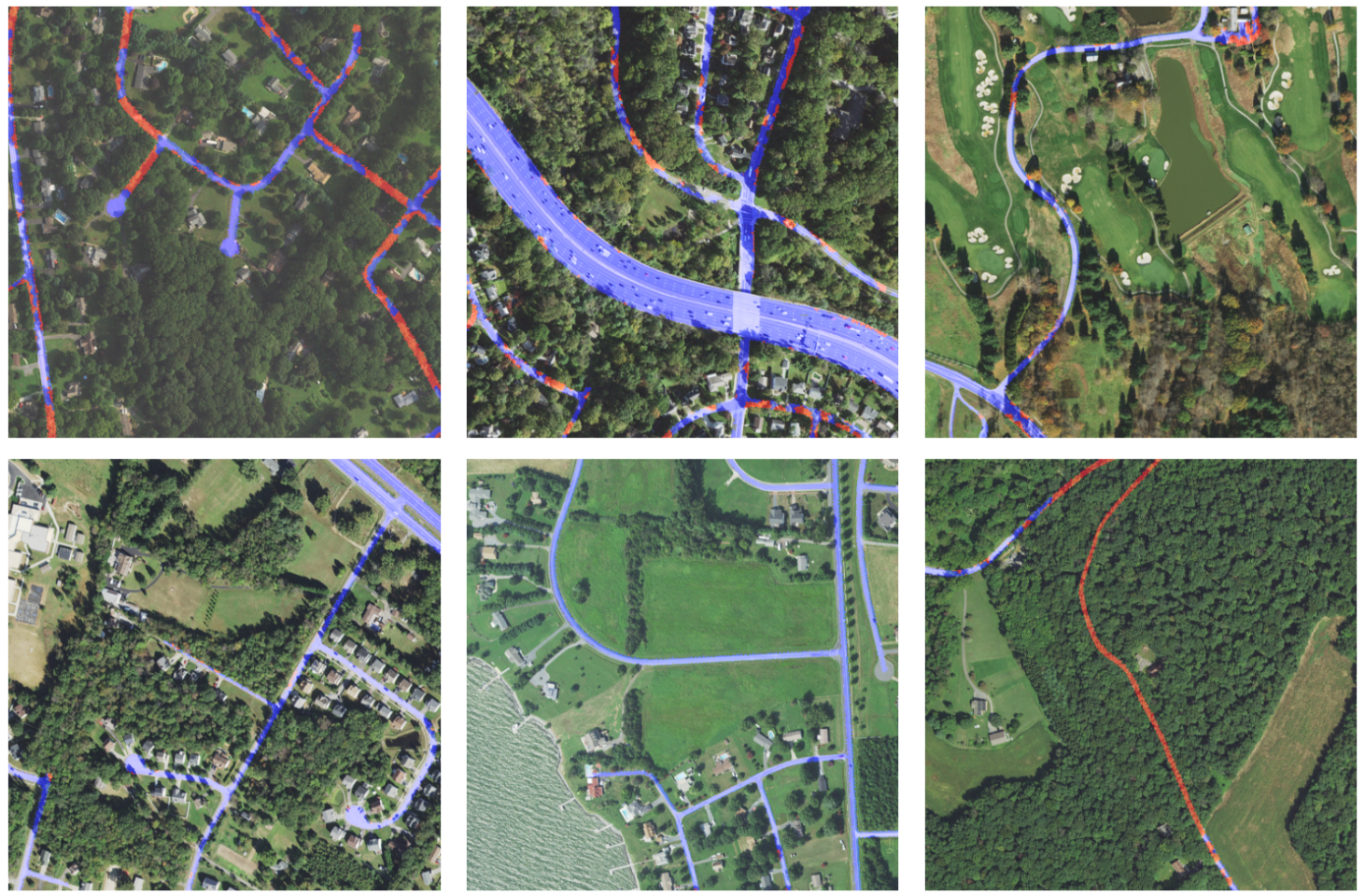 | We introduce a novel remote sensing dataset for evaluating a model’s ability to learn long-range spatial dependencies in aerial imagery by performing road extraction while containing large gaps occluded by tree canopy. |
Weak Labeling for Cropland Mapping in Africa
Gilles Hacheme, Akram Zaytar, Girmaw Tadesse, Caleb Robinson, Rahul Dodhia, Juan Ferres, Stephen Wood. "Weak Labeling for Cropland Mapping in Africa." arXiv preprint arXiv:2401.07014, 2024.
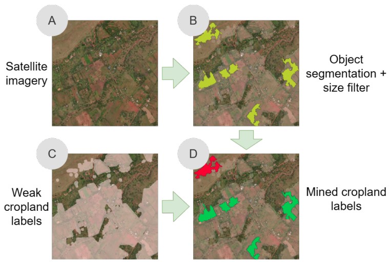 | We propose a simple method for extracting stronger labels from weak cropland labels and an unsupervised segmentation of satellite imagery. We show, in a scenario in Kenya where we only have 33 human-annotated labels, that adding strong labels mined by our method increases the F1 score for the cropland category from 0.53 (without mining) to 0.84. |
Analyzing Decades-Long Environmental Changes in Namibia Using Archival Aerial Photography and Deep Learning
Girmaw Tadesse, Caleb Robinson, Gilles Quantin Hacheme, Akram Zaytar, Rahul Dodhia, Tsering Wangyal Shawa, Juan M Lavista Ferres, Emmanuel H Kreike. "Analyzing Decades-Long Environmental Changes in Namibia Using Archival Aerial Photography and Deep Learning." arXiv preprint arXiv:2404.08544, 2024.
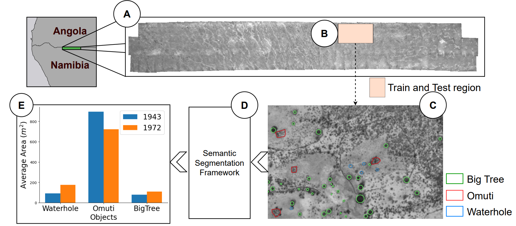 | We train and validate semantic segmentation models on historical aerial imagery from 1943 and 1972 for identifing trees, omuti (homesteads), and waterholes. These features are important for understanding how northern Namibia has changed over time. We observe average F1 scores of 0.661 and 0.755 for the 1943 and 1972 imagery respectively. Finally, we run our 1972 model over 5,000 square kilometers to get a first look at the historical population distribution in this area. |
Fields of The World: A Machine Learning Benchmark Dataset For Global Agricultural Field Boundary Segmentation
Hannah Kerner, Snehal Chaudhari, Aninda Ghosh, Caleb Robinson, Adeel Ahmad, Eddie Choi, Nathan Jacobs, Chris Holmes, Matthias Mohr, Rahul Dodhia, Juan M Lavista Ferres, Jennifer Marcus. "Fields of The World: A Machine Learning Benchmark Dataset For Global Agricultural Field Boundary Segmentation." arXiv preprint arXiv:2409.16252, 2024.
 | We present Fields of The World (FTW) – a novel ML benchmark dataset for agricultural field instance segmentation spanning 24 countries on four continents (Europe, Africa, Asia, and South America). FTW is an order of magnitude larger than previous datasets with 70,462 samples, each containing instance and semantic segmentation masks paired with multi-date, multi-spectral Sentinel-2 satellite images. |
talks
Talk 1 on Relevant Topic in Your Field
Published:
This is a description of your talk, which is a markdown files that can be all markdown-ified like any other post. Yay markdown!
Conference Proceeding talk 3 on Relevant Topic in Your Field
Published:
This is a description of your conference proceedings talk, note the different field in type. You can put anything in this field.
teaching
Teaching experience 1
Undergraduate course, University 1, Department, 2014
This is a description of a teaching experience. You can use markdown like any other post.
Teaching experience 2
Workshop, University 1, Department, 2015
This is a description of a teaching experience. You can use markdown like any other post.