
Analyzing Decades-Long Environmental Changes in Namibia Using Archival Aerial Photography and Deep Learning
Girmaw Tadesse, Caleb Robinson, Gilles Quantin Hacheme, Akram Zaytar, Rahul Dodhia, Tsering Wangyal Shawa, Juan M Lavista Ferres, Emmanuel H Kreike. "Analyzing Decades-Long Environmental Changes in Namibia Using Archival Aerial Photography and Deep Learning." arXiv preprint arXiv:2404.08544, 2024.
We train and validate semantic segmentation models on historical aerial imagery from 1943 and 1972 for identifing trees, omuti (homesteads), and waterholes. These features are important for understanding how northern Namibia has changed over time. We observe average F1 scores of 0.661 and 0.755 for the 1943 and 1972 imagery respectively. Finally, we run our 1972 model over 5,000 square kilometers to get a first look at the historical population distribution in this area.
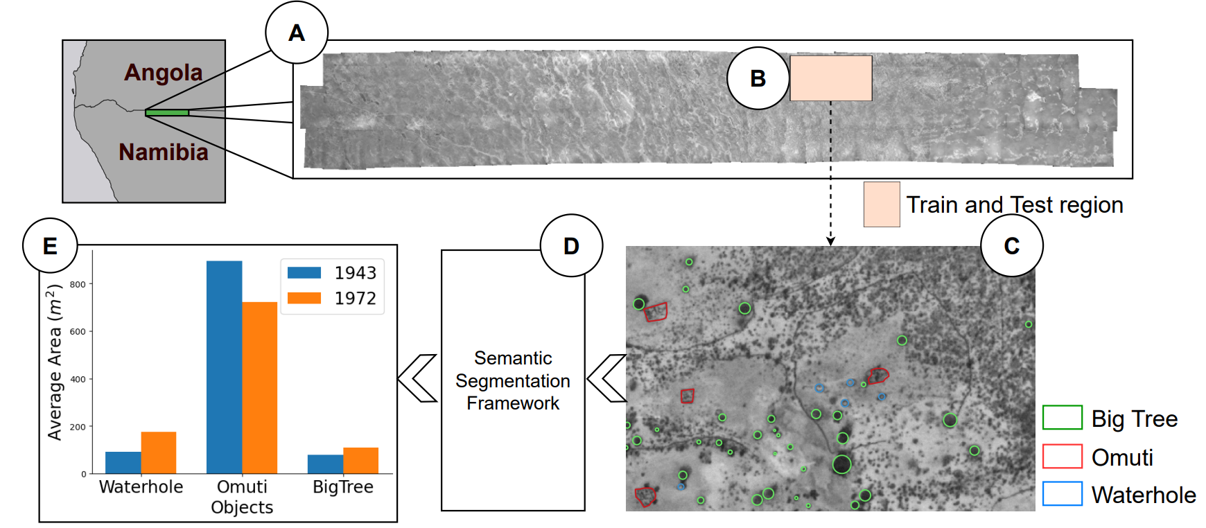
Figure 1. Overview of the proposed approach. Our study focuses on identifying objects of interest from decades-long aerial photos (1943-1972) to study long-term environmental changes in: (A) the Oshikango region (~5000 km2) in the North-Central Namibia; (B) a 45km2 area in Oshikango region was sparsely annotated and used as train and test region in our framework; (C) representative examples were annotated for the classes: Big Tree, Omuti and Waterhole; (D) a deep learning framework that aims to apply a semantic segmentation on the aerial photos and trained with different strategies; (E) insights are extracted to understand the change between 1943 and 1972.
Cite as:
@article{tadesse2024analyzing,
  title={Analyzing Decades-Long Environmental Changes in Namibia Using Archival Aerial Photography and Deep Learning},
  author={Tadesse, Girmaw Abebe and Robinson, Caleb and Hacheme, Gilles Quentin and Zaytar, Akram and Dodhia, Rahul and Shawa, Tsering Wangyal and Ferres, Juan M Lavista and Kreike, Emmanuel H},
  journal={arXiv preprint arXiv:2404.08544},
  year={2024}
}